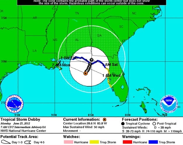
BOSTON, June 25, 2012 – According to catastrophe modeling firm AIR Worldwide, Tropical Storm Debby is the fourth named storm of the 2012 Atlantic hurricane season, currently has maximum sustained winds of 50 miles per hour and a minimum central pressure of 993 millibars, making it a weak tropical storm on the Saffir-Simpson Hurricane Wind Scale. Debby was about 105 miles south of Panama City (population 36,484), as of the National Hurricane Center’s (NHC) 7:00 am advisory today. The center is currently stationary in the Gulf of Mexico, and Debby is not expected to make landfall until later in the week.
The NHC’s most likely track brings Debby towards Florida’s panhandle, near Panama City, late Friday or early Saturday, June 30, at tropical storm intensity. A tropical storm warning is currently in effect for the Alabama-Florida border eastward to Suwannee River, as well as south of the Suwannee River to Englewood, along Florida’s western coast.
“Due to its slow forward motion, the storm could pose a serious flooding threat,” said Dr. Tim Doggett, principal scientist at AIR Worldwide. “Debby’s rainfall footprint currently extends from Pensacola, Florida north to near Macon, Georgia,and south and east to Fort Lauderdale, Florida. Some Florida weather stations have recorded between two to six inches of rain as of today, Monday, June 24, due to the system. Thunderstorm activity has also been reported and there have already been nine tornado reports in southern Florida as of today; tornado watches have been posted for much of western Florida.”
“At present, Debby is not expected to intensify dramatically as it tracks north; its maximum sustained winds could reach 65 mph by Thursday or Friday. However, confidence in both the intensity and track is low at this time and the dynamical forecast models are in considerable disagreement.”
Assuming that the NHC’s most likely track holds, Debby’s tropical storm-force winds will begin to interact with land several hours before landfall. After landfall, it is expected to weaken, reaching tropical depression strength by late Saturday, or early Sunday. Its most substantial effect throughout the region will likely be from flooding.
Dr. Doggett continued, “Wind damage in Tropical Storm Debby’s path at landfall is not expected to be severe if current forecasts hold. Damage to non-structural elements such as signage and awnings may occur, while unprotected windows could be broken as a result of wind-borne debris. Building code in Florida is both strict and strictly enforced.”
According to AIR, While Debby is projected to track north-northwest towards Panama City, the entire western Florida coastline and the southern Alabama coastline are expected to experience rain throughout the week, and could be threatened by flooding. Additionally, any changes in the track and intensity of the current forecast for Debby could put parts of the Florida coast at risk from wind.
AIR’s will continue to monitor this storm and will provide additional information as events warrant.

