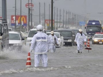
 BOSTON, Sept. 21, 2011-According to catastrophe modeling firm AIR Worldwide, after crossing over more than 350 kilometers of the main Japanese island of Honshu,Typhoon Roke, the 15th named storm of the 2011 Northwest Pacific typhoon season, has moved out to sea and is currently headed toward the Kuril Islands, northeast of Hokaido. Roke passed to the west of Tokyo early yesterday evening local time.
“Roke made landfall about 250 kilometers southwest of Tokyo in Shizuoka Prefecture near Hamamatsu City at about 2:00 pm local time,” said Dr. Peter Sousounis, principal scientist at AIR Worldwide. “Roke had intensified rapidly from a Category 1 typhoon to a Category 3 typhoon during its approach to Japan, but it weakened before making landfall. Roke came ashore with winds of about 180 kilometers per hour-a borderline Category 2/Category 3 storm-and moved to the northeast (toward Tokyo) at about 46 km/h. Weakening after landfall, Roke’s winds during most of the storm’s passage across Honshu were at about 150 km/h.”
As of the Japan Meteorological Agency’s (JMA) 14:00 UTC analysis today (11:00 pm local time), Typhoon Roke had maximum sustained winds of 150 km/h with gusts up to 213 km/h. Roke’s center was located over the ocean about 220 km northeast of Fukushima, the city that was damaged so severely by the Tohoku tsunami and earthquake in March of this year. Roke’s tropical storm force winds extend outward about 70 km to the northwest and 190 km to the southeast. The storm is currently moving to the northeast at about 68 km/h.
Dr. Sousounis continued, “Minimal structural damage from wind is expected given Roke’s wind speeds over land.” According to AIR, in the countryside, wood frame homes dominate residential construction. Many have heavy, clay tile roofs meant to prevent damage from wind. At Roke’s wind speeds, these buildings are expected to have minor roof damage and little or no structural damage. Larger multi-family apartment buildings, as well as commercial and industrial structures, are generally engineered and made of reinforced concrete or steel, making them less vulnerable to Roke’s winds. They would be expected to experience minor damage to roofs and sidings, with minor to moderate damage to decorative elements and signage.
Modern urban structures are similarly expected to withstand Roke’s wind speeds with minimal damage; Japan has strict and well-enforced construction codes. Thus, the chief impact from Roke is expected to be flood damage and the effects of flood, such as mudslides. Flood damage in Japan is not automatically included in wind policies.
According to AIR, the vulnerability of buildings to flood damage varies by construction type. For a given flood depth, a residential wood-frame building is expected to sustain more damage than a residential masonry building. Concrete construction is less vulnerable to flood than steel or masonry. Commercial and apartment buildings usually have stronger foundations than residential buildings,and are thus better able to resist flood loads.
Building height also affects flood damage. Because damage is usually limited to the lower stories of a building, high-rise buildings will experience a lower damage ratio-the repair cost compared to the total replacement value of the building-than low-rise buildings because a smaller proportion of the building is affected.
Typhoon Roke’s heavy rains and accompanying flooding has caused extensive evacuations, widespread transportation disruptions, and power outages. As much as 80 millimeters of rain per hour (3.1 inches) has fallen in central Honshu, and JMA has issued warnings for landslides and flooding throughout the island. Over the last three days, total precipitation amounts have exceeded 400 mm at about a doze nmonitoring stations; Tokushima, which is southwest of Roke’s landfall on Shikoku, has reported an accumulation of 600 mm.
Dr. Sousounis concluded, “At present, according to the Joint Typhoon Warning Center (JTWC), the circular movement of Roke’s winds-its deep convection-is weakening rapidly. Most of the deep convection is now in Roke’s northeast quadrant. The JTWC expects Roke to undergo extra-tropical transition over the next twelve hours as it tracks northeastward rapidly, and thereafter for the storm to dissipate, although there remains a slight chance it could regenerate.”
AIR is analyzing the latest meteorological and track data concerning Typhoon Roke and has begun simulating the storm using the AIR Northwest Pacific Basinwide Typhoon Model. AIR will issue updates as warranted by events.
