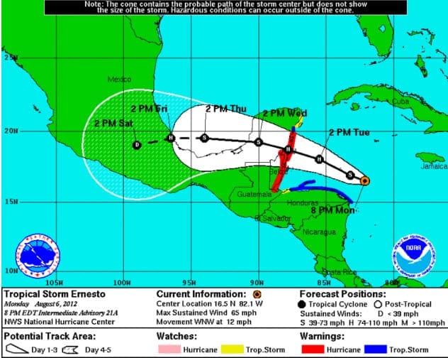
BOSTON, August 6, 2012 – According to catastrophe modeling firm AIR Worldwide, as of 11:00 AM Monday, Tropical Storm Ernesto is increasing in intensity and has maximum sustained winds of 65 mph. The storm’s forward speed has slowed to 9 mph, which has allowed it to become more organized and begin forming an eye.
“Just 24 hours ago, Ernesto had a forward speed of 21 mph due to a strong ridge of high pressure that had built north of its track, which kept it moving westward instead of curving northward,” said Scott Stransky, senior scientist at AIR Worldwide. “Now that the storm has slowed, it has begun curving northwards and is expected to make landfall along the Belize/Mexico border in 36-48 hours as a Category 1 hurricane. However, with the increased time over the water, the storm may strengthen still further, and there is a possibility that it could reach Category 2 strength before landfall. The storm is expected to cross the Yucatán Peninsula and could make a second landfall in Mexico by Friday. Mexico has issued a hurricane warning for the east coast of the Yucatán Peninsula from Chetumal to Punta Allen.”
In Kingston, Jamaica, which is now well north and east of the westward moving storm, sustained wind speeds of 37 mph were recorded and the area has received 1.73 inches of rain. Only minor damage was sustained and the storm did not cause any major disruptions. The Cayman Islands, which are also outside of the radius of tropical storm force winds, have reported 32 mph wind gusts, and some strong wind gusts are expected to continue through today. Heavy rain was also reported in Hispaniola and Puerto Rico.
Stransky continued, “Despite the winds and rain that Ernesto brought to several Caribbean islands over the weekend, only the most vulnerable structures would have potentially been damaged from this storm. In Jamaica, most buildings in the major urban areas such as Kingston are constructed of brick or reinforced concrete with tiled or cement roofs, which would be largely unaffected by Ernesto’s relatively low wind speeds. Poorly constructed shanty-type homes can be found across the country, and while these may be vulnerable to the observed wind speeds, they would not be insured. In the Cayman Islands, residential construction is a mix of wood, unreinforced masonry, and reinforced masonry. The Planning Department requires structures to be built to specifications of the Standard Building Code (1999). These conditions led to admirable performance during Hurricane Ivan (2004), indicating that the structures in this region should experience very minimal damage during this significantly weaker event. As in regions previously affected, flooding due to precipitation is a concern for non-engineered structures, but the forward speed of the storm has reduced this threat.”
“While the storm is set to pass close to Honduras and bring winds to its northern coast, significant insured losses are not anticipated. There is no building code in Honduras, but insurance penetration in the country is low and Ernesto’s current projected track does not directly impact the country’s major exposure centers.”
Elsewhere in the Atlantic, former tropical storm Florence has decayed to a post-tropical cyclone and is not anticipated to be a threat to any land areas.
AIR will continue to monitor these events and will provide updates if warranted.
