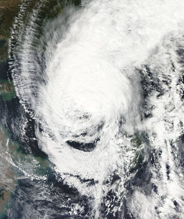
 According to catastrophe modeling firm AIR Worldwide, Typhoon Sanba made landfall on September 17 just before noon local time (3:00 UTC) in South Gyeongsang Province on the southern coast of South Korea. Maximum sustained winds at landfall were around 150 km/h (equivalent to a Category 1 hurricane on the Saffir-Simpson Scale). Sanba subjected both South and North Korea to winds and heavy rains in its north-northeast trek across the peninsula, causing flooding and landslides, transportation service disruptions, and power outages. Significant insured losses in South Korea are not expected from this event.
“As Sanba entered a region of cooler waters and increased vertical wind shear on Sunday, the storm weakened on its approach to South Korea,” said Dr. Peter Sousounis, senior principal atmospheric scientist at AIR Worldwide.
Sustained winds dropped from 194 km/h when it reached Okinawa, Japan, on Sunday morning, to around 150 km/h at the time of its landfall earlier today, according to the Japan Meteorological Administration (JMA). Peak recorded 1-minute sustained wind speeds were 104 km/h on western Jeju Island, and 98 km/h on the mainland. Due to the sparse observational network density in that region, higher sustained wind speeds were likely to have occurred but not recorded.
“Because Sanba began extratropical transitioning prior to landfall, most of the precipitation was north of the storm center and arrived several hours before landfall. The maximum recorded 24-hour rainfall accumulation totaled 215 mm, with several stations observing more than 150 mm. Sanba further weakened to tropical storm status after moving inland.”
As of the JMA’s 15:45 UTC advisory today, Sanba has exited the Korean peninsula and is currently located over the Sea of Japan. It has maximum 1-minute sustained wind speeds of approximately 95 km/h and is moving north at 45 km/h. Sanba is expected to reach Russia on Tuesday morning local time, close to the Chinese border, before dissipating some time during the day.
Sanba missed a direct hit on South Korea’s second largest metropolitan area of Busan (population of more than 4 million) by about 100 km. Peak sustained winds in Busan were between 55 and 65 km/h and total precipitation was 111 mm. Only minimal damage is expected in that region.
Dr. Sousounis continued, “At Sanba’s reported wind speeds, structural damage to well-built structures is expected to be minimal. Wind damage is likely to be limited to roofs and wall claddings, and to signage, traffic lights, and trees. Further, Sanba’s relatively fast forward speed limits rainfall accumulation in any given area, reducing the chances of widespread flooding.”
Sanba uprooted trees, blew away signs and billboards, and temporarily knocked out power to 450,000 households (more than 90% since restored) on Jeju Island and southern portions of mainland South Korea. Heavy rains have triggered some landslides, and several dozen residential buildings were flooded on the island of Jeju, according to the National Emergency Management Agency.
AIR will continue to monitor the situation and will provide updates if warranted by events.

