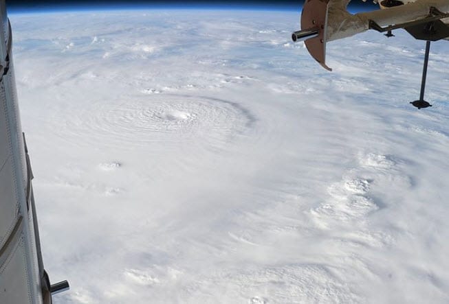
 According to catastrophe modeling firm AIR Worldwide, Super typhoon Bopha made landfall at 2100 UTC on the island of Mindanao with a central pressure of 930 mb and 10 min sustained winds of 100 kts (115 mph)). NASA-TRMM data indicate that there were maximum rainfall rates of 50-75 mm/hr at landfall. According to AIR, given that insurance penetration in this area is around 10% to 20%; insured losses are not expected to be high as a result of this event.
“Bopha is a unique storm due to its intensity and it’s extremely southern track,” said Dr. Peter Sousounis, senior principal atmospheric scientist at AIR Worldwide. ” In fact, Bopha is the strongest typhoon to track through the southern Philippines since Super Typhoon Mike (“Ruping” in the Philippines) in November 1990. With a genesis point just 3.8 degrees north of the equator, Bopha is also the most southerly typhoon on record in the western North Pacific Basin and the second most southerly overall. Only Typhoon Kate, in 1970, formed closer to the equator.”
Bopha is currently moving west northwest across the Philippines at a speed of 19mph, as the low level circulation center that defines the storm has just emerged over the Southern Bohol Sea. An intense storm with an average-sized wind field, Bopha was equivalent to a Category 4 hurricane on the Saffir-Simpson scale at landfall but has since weakened to a Category 1 equivalent storm with reported wind speeds of 90-95 mph.
Dr. Sousounis continued, “The southern island of Mindano experienced a direct hit from Typhoon Bopha as the storm came ashore in Baganga, Davao Oriental province early Tuesday. Bopha is the strongest storm to hit the Philippines this year; 56,000 people have been relocated to evacuation centers. The relatively large cities of Cagayan de Oro, Davao City, and Dumaguete City were hard hit.”
According to AIR, while Super-Typhoon Bopha is impacting a region of the Philippines that is largely rural and agricultural; large, populated cities such as Davao City and Cagayan de Oro City and small cities such as Dumaguete City and Puerto Princesa are also in the path of the storm. Given that the region is generally less urbanized and less accustomed to typhoons, construction types and standards are lower than those in the Northern Islands. While reinforced masonry are typical, light materials, such as wood frame with galvanized iron, and aluminum roofs are frequently used for residential buildings in these rural areas making them more vulnerable when compared with those in neighboring Manila, Hong Kong or Taiwan.
Dr. Sousounis concluded, “As Bopha completes its track across the Philippines in the next 6 hours or so, it will emerge on the west side a few hundred kilometers from Manila. Although Bopha will remain far enough south to spare Manila the brunt of the storm, some rain and wind are possible in the Philippine capital through early Wednesday as estimated rainfall rates of 10 – 18 mm per hour are expected within a 500 km diameter of the typhoon. Storm surge of up to 5.5 meters above normal has been reported in coastal regions, and inland flooding from high levels of precipitation is also a risk.”
“The storm weakened considerably due to its interaction with land but is expected to remain a typhoon as it is located in a region of low vertical wind shear- a condition conducive to intensification. Some weakening is expected over the next 6 hours as the storm further interacts with Negros Island, but the storm should intensify as it moves over the warmer sea waters of Sulu, while remaining in a low wind shear environment. By the time the storm arrives in the southern China Sea, increasing wind shear and cooler water will likely result in a more dramatic weakening of the storm.”
AIR will continue to monitor Typhoon Bopha and will provide updates as necessary.

