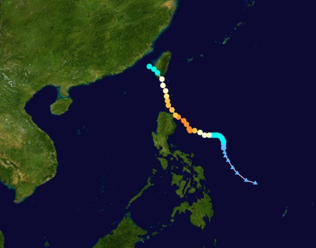
 BOSTON, Aug. 30, 2011 – According to catastrophe modeling firm AIR Worldwide, Tropical Storm Nanmadol is moving slowly at about 3.2 km/h across the Taiwan Strait toward a landfall in China’s Fujian province sometime in the next 12 hours. Nanmadol’s current sustained winds are at about 85 km/h, having weakened to tropical storm strength after it made a landfall on southernmost Taiwan early Monday morning local time as a Category 1 typhoon. Nanmadol currently is heading toward Xiamen, Fujian’s second-largest city (population 1.5 million, 2010).
As of the Japan Meteorological Agency’s (JMA) 12:00 UTC analysis (8:00 pm local time in China), Nanmadol had maximum sustained winds of 85 km/h with gusts up to 128 km/h. The center was located about 60 km east-southeast of Xiamen; its tropical storm-force winds stretch across 370 km.
At present, Nanmadol is poised to strike somewhere near to the Fujian “Min Nan Golden Triangle” made up of the three large cities of Xiamen, Quanzhou, and Zhangzhou, and which together account for 40 percent of the GDP of Fujian province. This is an area that has developed very rapidly in recent decades. It thus includes both urban and rural areas, broad residential areas, and many light-industry facilities.
According to AIR, residential homes in the region where Nanmadol is expected to make landfall consist mostly of masonry construction. Apartment buildings, which have become common in recent years, are made largely of reinforced concrete and confined masonry. Commercial and industrial structures are also largely of reinforced concrete, but older structures are of unreinforced masonry and some confined
masonry.
“At Nanmadol’s expected wind speeds at landfall-about 80 km/h-only minor damage is expected to the general building stock. For apartment buildings and commercial facilities, expected damage is very low to none,” said Dr. Peter Sousounis, principal scientist at AIR Worldwide. “For houses, wind damage can be more considerable. Trees may be blown over if their root structures are sufficiently weakened by the storm’s heavy rains, and they can cause damage to nearby buildings. Minor to moderate levels of damage to light fabrication facilities and warehouses, especially in the case of older structures, and to signage, also can be expected. All in all, flooding is expected to cause more damage than wind, especially to the poorly constructed houses in the hilly and mountainous countryside, where mudslides
and river-overflow are substantial dangers.”
Insurance penetration in China generally is low, and especially for residential structures. Accordingly, although damage from wind, flood, and landslides is expected, insured losses should be low.
Reported Impacts: Taiwan
Nanmadol struck southernmost Taiwan at 4:25 am local time Monday morning (20:25 UTC, August 28) with the intensity of a Category 1 hurricane on the Saffir-Simpson Hurricane Wind Scale. Its sustained winds at landfall were 119 km/h (just at the borderline of Category 1), gusting to 155 km/h. “Although Nanmadol remained over the island for only a few hours, it weakened in its interaction with Taiwan’s mountains and was downgraded to a tropical storm later in the day,” added Dr. Sousounis.
About 40,000 households in southern and eastern Taiwan lost power and scores of roads and bridges were closed because of heavy rains. This was Taiwan’s first typhoon landfall of the year, and government officials were exercising extreme caution in their preparations after having been strongly criticized for an inadequate response in 2009, when Typhoon Morakot caused extensive damage.
“Mountainous regions of Taiwan have received between 70 and 110 centimeters of rain from Tropical Storm Nanmadol, and rain continues to fall in many areas,” said Dr. Sousounis. “One area, Hengchun Township, received 51 cm in two days, with 22 cm having fallen in one eight-hour period. The rain, squalls, and gusty winds have caused significant damage to crops in several areas of the east and south.”
Reported Impacts: Philippines
Before making landfall on Taiwan, Nanmadol made landfall three days earlier, on August 26th, in the Philippines. Nanmadol’s winds just before striking northern Luzon had risen to just below 250 km/h, only a kilometer or two per hour lower than Category 5 status-the highest. Large parts of northern Luzon remain without power and more than 60,000 people are still not able to return to their homes from
evacuation centers. In addition, nearly another 60,000 people were cut off by Nanmadol’s flooding and other damage.
Forecast Track and Intensity
“Nanmadol is the eleventh named storm of the 2011 Pacific typhoon season,” continued Dr. Sousounis. “At the speed of its present forward movement, Nanmadol is expected to reach the Fujian coast in the early hours (local time) of Wednesday morning. Nanmadol’s landfall will probably coincide with an astronomical high tide, and its waves are expected to crest at from two to three-and-a-half meters along Fujian’s coast.”
Given these and other precautions undertaken, insured losses in Fujian province from Tropical Storm Nanmadol are not expected to be large. AIR is continuing to monitor Nanmadol and will provide additional information as events warrant.
