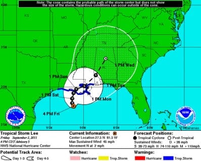
 BOSTON, Sept. 2, 2011 – According to catastrophe modeling firm AIR Worldwide, Tropical Depression 13 has strengthened to Tropical Storm Lee. Lee is currently 200 miles southeast of Cameron, Louisiana, and 210 miles southwest of the mouth of the Mississippi River. Maximum sustained winds are 40 mph, up from 35 mph earlier today, and Lee’s tropical storm-force winds extend outward for 200 miles. The storm is moving very slowly north through the Gulf of Mexico, at 2 mph.
A tropical storm warning has been issued for Pascagoula, Mississippi, west to Sabine Pass, Texas, including the city of New Orleans (the warning for New Orleans encompasses Lake Pontchartrain). By late afternoon or evening today, the locations in this warning cone could begin to experience tropical storm conditions.
“The storm is a significant threat because it is slow-moving, and the potential exists for major flooding in New Orleans and other locations along the coast,” said Dr. Tim Doggett, principal scientist at AIR Worldwide. “Over the weekend, the storm could bring 10 to 15 inches of rain to southern areas of Louisiana, Mississippi and Alabama, and as much as 20 inches in New Orleans and other locations.”
Wind gusts near 60 mph are being reported on oil rigs north and east of the system’s center.
Dr. Doggett continued, “Lee is expected to slowly intensify as it tracks north; its maximum sustained winds could reach 65 mph by Sunday. Intensification of the system in the Gulf is in spite of wind shear associated with an area of upper level low pressure. Given the warm sea surface temperatures-from which the storm can continue to draw strength-only the area of shear inhibits Lee from reaching hurricane strength at this time. Fortunately, the shear is forecast to persist for the next 24 hours (or more), and the NHC’s forecast keeps the storm at tropical storm strength until landfall in Louisiana sometime over the weekend or on Monday morning.”
“That said, confidence in the intensity (and track) is minimal at this time. The sheer in the Gulf may still weaken, and if the storm remains over water for an extended period as this weakening happens (which some models are forecasting), Lee may achieve hurricane status before landfall. Thus, though the wind threat from the storm is low now, at least compared to major hurricanes, it could increase.”
In addition to uncertainty regarding intensity, the operational forecast models are not in agreement about where the meandering storm will track. The NHC track indicates it could make landfall on the coast of southern Louisiana Monday morning, though it could linger near the Louisiana coast on Saturday evening, meaning torrential rains would pound the region for nearly two days before the storm actually came ashore. The storm may also make landfall earlier than predictions indicate if its forward speed increases. It could produce flooding rains from Texas to Georgia.
“The current intensity and flooding potential from Tropical Storm Lee bear similarities to 2001’s Tropical Storm Allison, which-after dropping heavy rain on the upper Texas coast-returned to the Gulf, lingered there, and then made landfall in Louisiana, after which it moved across the southeast United States and Mid-Atlantic, including Pennsylvania,” commented Dr. Doggett. “Altogether, Allison caused insured losses of USD 2.5 billion (or USD 4.9 billion, in current dollars), despite being a tropical storm. Allison’s peak rainfall was 40 inches, and its worst impact from flooding was in Houston-west of where Lee is likely to track. In downtown Houston, Alison caused severe damage to hospitals and businesses.”
Tropical Storm Lee is the 12th named storm of the Atlantic hurricane season. AIR is continuing to monitor this event and will provide updates as warranted.
###
For more information, contact:
Kevin Long
AIR Worldwide
617-267-6645
