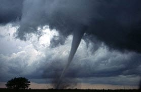
 BOSTON, April 4, 2012 – According to catastrophe modeling firm AIR Worldwide, just one month after a notable tornado outbreak across parts of the Midwest and the Southeast, a severe thunderstorm on April 3 spawned up to 10-12 tornadoes that caused extensive, though localized, damage due to high winds, heavy rain, and hail in seven counties in the Dallas-Fort Worth region of Texas. The suburban communities of Arlington and Lancaster experienced significantly damaged buildings, with several homes and businesses flattened by the tornadoes. In Lancaster alone, 300 structures were damaged by the tornadoes.
“On average, April and May are the most active months for severe thunderstorm activity in Central Texas, and Tuesday’s activity was typical for the time of year. However, given the location of this specific cluster of tornadoes, the impact of these storms was magnified,” said Dr. Tim Doggett, principal scientist at AIR Worldwide.
“Severe thunderstorm activity developed Tuesday, April 3 as a jet stream disturbance interacted with a cold front moving eastward across the southern Great Plains,” commented Dr. Doggett. “Although the conditions were initially only marginally favorable for severe weather, by mid-Tuesday the warm humid air from the Gulf of Mexico had fueled a line of thunderstorms. These storms quickly intensified as they moved north into the Dallas-Fort Worth area.”
Preliminary severe storm reports available Tuesday night indicated that up to 10 to 12 tornadoes may have impacted the area. Continued damage surveys over the next few days are expected to clarify the number of tornadoes spawned by this storm.
Dr. Doggett continued, “Several tornadic supercell thunderstorms formed within the line, aided by rotation provided by the jet stream disturbance moving overhead. The first tornadic storm formed south of Dallas-Fort Worth, between Fort Worth and Arlington. A tornado was reported in Lancaster, which later crossed Highway I-20 in the Kennedale area and moved northeast toward Arlington before dissipating. A second tornadic storm produced additional tornadoes further east. A tornado formed south of the city of Dallas, which moved to the northeast before ending in Mesquite. A second apparent tornado from this storm tracked between Forney and Terrell, moved northeastward and dissipated before reaching Highway I-30.”
As of Wednesday morning, the storm system has moved northeast and is predicted to generate severe thunderstorm activity in the lower Mississippi Valley and Tennessee Valley. According to the NOAA Storm Prediction Center, the states at greatest risk for severe storms include Louisiana, Mississippi, Arkansas, Alabama, and western Tennessee. Although tornadoes may be produced by these forecasted storms, the large hail and strong winds are the most likely hazards.
Until the National Weather Service completes damage surveys of the affected regions of North Texas, the full impact of these tornadoes will not be known. The National Weather Service plans to issue public information statements by the evening of Wednesday, April 4, with further damage information. However, as of Wednesday morning, fully 650 homes and many businesses in suburban communities around Dallas have been damaged. Powerful winds peeled roofs from homes, leveled businesses, and tossed empty big rigs nearly 100 feet into the air. Nearly 14,000 homes and businesses in the region are still without electricity.
According to AIR, in general, residential structures in the affected area are wood frame buildings that are more vulnerable to strong winds and windborne debris than masonry structures. Although commercial buildings tend to be more resistant to damage than residential structures or automobiles, they exhibit a broader range of damage due to variations in their construction and design. Light metal structures are the most vulnerable to high winds, and can experience severe or total destruction from tornadoes classified as EF-2 or higher.
For all types of structures, roofs are often the first component to be damaged by the tornado. After roof damage is initiated by the removal of a single shingle, neighboring shingles are easily peeled from the roof. Tornado winds can also peel off unsecured roof slates, roll metal roofs, and damage windward overhangs and eaves. In the direct path of a tornado, roof failure weakens the lateral support of the walls and contributes to the building’s collapse. On the periphery of the storm track, less severe damage is expected.
The AIR severe thunderstorm team is continuing to monitor the situation and will provide updates if warranted.
