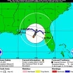
BOSTON, June 25, 2012 – According to catastrophe modeling firm AIR Worldwide, Tropical Storm Debby is the fourth named storm of the 2012 Atlantic hurricane season, currently has maximum sustained winds of 50 miles per hour and a minimum central pressure of 993 millibars, making it a weak tropical storm on the Saffir-Simpson Hurricane Wind Scale. Debby was about 105 miles south of Panama City (population 36,484), as of the National Hurricane Center’s (NHC) 7:00 am advisory today. The center is currently stationary in the Gulf of Mexico, and Debby…
Read MoreTag: tropical storm
AIR Estimates Insured Losses from Typhoon Roke at Between JPY 12 billion (USD 150 million) and JPY 46 billion (USD 600 million)
BOSTON, Sept. 22, 2011 -Catastrophe modeling firm AIR Worldwide estimates insured losses from Typhoon Roke at between JPY 12 billion (USD 150 million) and JPY 46 billion (USD 600 million). Typhoon Roke, the 15th named storm of the 2011 Northwest Pacific typhoon season, made landfall near Japan’s Hamamatsu City in Shizuoka Prefecture at 2:00 pm local time (05:00 UTC) on September 21. Maximum sustained winds at landfall were 180 km/h, making Roke a strong Category 2 storm. Note that this is the same range announced for Typhoon Talas on September…
Read MoreTropical Storm Lee Threatens Much of the Gulf Coast with Heavy Rainfall; Landfall
BOSTON, Sept. 2, 2011 – According to catastrophe modeling firm AIR Worldwide, Tropical Depression 13 has strengthened to Tropical Storm Lee. Lee is currently 200 miles southeast of Cameron, Louisiana, and 210 miles southwest of the mouth of the Mississippi River. Maximum sustained winds are 40 mph, up from 35 mph earlier today, and Lee’s tropical storm-force winds extend outward for 200 miles. The storm is moving very slowly north through the Gulf of Mexico, at 2 mph. A tropical storm warning has been issued for Pascagoula, Mississippi, west to…
Read MoreTyphoon Talas Heads for Japan
BOSTON, Sept. 2, 2011 – According to catastrophe modeling firm AIR Worldwide, Typhoon Talas formed on August 25 as the Japan Meteorological Agency’s (JMA) 12th named storm of the 2011 Northwest Pacific typhoon season. The typhoon is located south of Osaka, Japan, moving 12 km/h in a north-northwest direction. Talas is a large storm, with tropical storm force winds extending up to 650 km from its center. Maximum 10-min sustained wind speeds are 120 km/h (with gusts up to 175 km/h), making it a weak Category 1 hurricane on the…
Read MoreTropical Storm Nanmadol Poised for China Landfall after Battering Taiwan and Philippines
BOSTON, Aug. 30, 2011 – According to catastrophe modeling firm AIR Worldwide, Tropical Storm Nanmadol is moving slowly at about 3.2 km/h across the Taiwan Strait toward a landfall in China’s Fujian province sometime in the next 12 hours. Nanmadol’s current sustained winds are at about 85 km/h, having weakened to tropical storm strength after it made a landfall on southernmost Taiwan early Monday morning local time as a Category 1 typhoon. Nanmadol currently is heading toward Xiamen, Fujian’s second-largest city (population 1.5 million, 2010). As of the Japan Meteorological…
Read More
