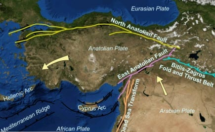
 According to catastrophe modeling firm AIR Worldwide, it is still in the early aftermath of the earthquake that struck near the city of Van in eastern Turkey, and damage assessments are only just emerging. Damage in the cities of Van and Ercis is widespread, and aftershocks, of which there have been more than 200, remain a concern. The U.S. Geological Survey has issued a moment magnitude estimate of 7.2 for the event and a relatively shallow focal depth of 20 km, which will have exacerbated the damage.
“The tectonic setting of Van province is dominated by the collision of Arabian and Eurasian plates,” said Dr. Mehrdad Mahdyiar, director, earthquake hazard at AIR Worldwide. “The Arabian Plate moves northward at a rate of about 15-20 mm/yr and collides with the Eurasian plate in eastern Turkey. The collision of the two plates squeezes the Anatolian plate in central and western Turkey to move westward, resulting in the formation of one of the longest strike-slip faults in the world-the Northern Anatolia fault. Many of Turkey’s most severe quakes occur on this fault, including the devastating 1999 Izmit earthquake.”
The quake lasted for more than 30 seconds and shaking was felt throughout the country, and as far away as parts of neighboring countries of Armenia, Azerbaijan, Georgia, Iran, Iraq, and Syria. The hardest hit areas appeared to be around the town of Ercis, where up to 80 multistory buildings collapsed, including student dormitories, apartment buildings and hotels. According to the prime minister’s emergency agency, the earthquake has destroyed or damaged 970 buildings in the region. Officials estimate the number of fatalities could be as high as 1,000.
According to AIR, in Turkey, ground floors are commonly used for commercial purposes, with residential units above. The large shop windows and other openings on the ground floor reduce the lateral resistance significantly, resulting in excessive deformation demands. Asmolen construction, a form of reinforced concrete frame that has a joisted floor slab made of hollow cement cinderblock, is commonly used in Turkey. During past AIR post-disaster surveys in Turkey, the blocks were often discovered to be not properly attached to the reinforced concrete floor, and floor damage such as the dislodging and falling of hollow blocks was widespread. Additional damage was observed due to structural irregularities, a lack of transverse reinforcement, and short columns. Following the catastrophic Izmit earthquake that killed nearly 20,000 people in 1999, the Turkish government introduced new construction codes that were intended to address these design deficiencies and ensure that new construction would withstand ground shaking similar to that produced by Monday’s earthquake.
“However, many buildings in Van will have been built before the new code,” stated Dr. Mahdyiar. “Moreover, code enforcement has long been an issue in Turkey; it was observed after the 1999 Izmit and Düzce earthquakes, for example, that many structures built in 1999 did not follow the 1998 regulations. Experts believe, however, that codes have been more seriously enforced after 2000. In 2006, the Turkish Earthquake Code was updated again, but its seismic provisions are similar to the existing 1998 code. Undoubtedly, many questions will be raised regarding code enforcement in the weeks ahead.”
Dr. Mahdyiar continued, “Today’s event occurred in a broad zone of compression caused by the collision of the Arabian and Eurasian plates. The event is located north of the Bitlis Suture Zone representing the main tectonic feature of the collision zone and situated about 150 km southwest of the triple-junction where the Arabian-Anatolian-Eurasian plates meet. Unlike central and western Turkey where earthquakes are concentrated along the Northern Anatolian and Eastern Anatolia faults, earthquakes in eastern Turkey are quite “diffuse;” that is, there is no predominate active structures that are known to control the locations of earthquakes. Mapped active faults are few and they do not necessarily represent where earthquakes have occurred or will occur in the future. Most of the earthquakes in eastern Turkey are strike-slip and thrust ruptures. The mechanism of today’s earthquake indicates an oblique thrust faulting, which is consistent with the tectonic stress field in the region.”
“The Anatolian Block is seismically very active. Within the past twenty years there have been seven earthquakes with magnitude of greater than 6.0, while the period 1939-44 saw five earthquakes with a magnitude greater than 7.0. Yesterday’s earthquake struck about 70 km from where a M7.3 earthquake occurred in November 1976 and killed thousands of people, and 1000 km from the devastating 7.6 Izmit earthquake, which killed nearly 20,000 people.”
Although a national earthquake insurance pool was established in Turkey in 2000 and participation is mandatory for all general insurance and reinsurance companies, earthquake insurance penetration is still generally low. In collaboration with the World Bank, the Turkish government and the private insurance industry, the TCIP (Turkish Catastrophe Insurance Pool) was established as a way to provide earthquake insurance cover for residential properties. The terms of TCIP coverage are relatively simple, with the losses covered up to a maximum of TRY 150,000 including a deductible of 2%. Insurance penetration, particularly in eastern Turkey, remain relatively low-between about 2-10% in the area impacted by yesterday’s earthquake.
AIR continues to collect and analyze the available ground motion data for this event. Information on potential insured losses from this event will be made available tomorrow.
