According to catastrophe modeling firm AIR Worldwide, Super Typhoon Haiyan, one of the most powerful tropical cyclones since modern record-keeping began, made landfall at 5:00 a.m. local time on November 8, 2013 (21:00 UTC on November 7) near Guiuan, on the Philippine island of Samar. At that time, the Japan Meteorological Agency (JMA) estimated a minimum central pressure of 895 millibars and maximum 10-minute sustained wind speeds of 266 km/h (165 mph). The Joint Typhoon Warning Center estimated maximum sustained wind speeds of 305 km/h (190 mph).
According to AIR, since its initial landfall, Haiyan has continued to track quickly to the west through the Philippine island chain, making several additional landfalls. The Tropical Rainfall Measuring Mission (TRMM) satellite-estimated precipitation shows that 350 millimeters (14 inches) of rainfall has fallen near low-lying coastal locations in the past 24 hours. The soils are already saturated from an earlier tropical depression that plowed through the region. A storm surge of 2.5 meters (8 feet) has been reported in some places, which is high enough to inundate areas near Leyte and Samar Islands. Surface wind speed observations near the storm center are currently unavailable, although information may become available in the coming days. Friction from land has disrupted the low-level inflow and circulation of Haiyan to some extent, but the storm remains very strong. As of the Japan Meteorological Agency’s 12:50 UTC November 8 advisory, the storm is currently moving west at 35 km/h mph (22 mph) with maximum 10-minute sustained wind speeds of 201 km/h (125 mph).
Local officials report that it is too early to assess the full extent of the damage. Haiyan has knocked out  power to entire provinces and local officials have conducted large-scale evacuations across coastal provinces. According to the Philippines Disaster Management Response Program, more than 12 million people have been affected, including the 2.5 million residents of Cebu City, the closest metropolitan area to the point of landfall. Ferry services have also been suspended.
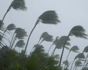
There have been reports of iron roofs torn off buildings and trees strewn across roads, making them impassable. Landslides have been reported in mountainous areas while coastal areas have been hit by swells, storm surges, and large waves. On Kayangel in Palau, a high storm surge damaged several house and downed trees.
Flooding remains a concern, especially given that Haiyan has already dropped copious amounts of rainfall across the region. The heavy rain has the potential to submerge important crops, including sugarcane, and it has been estimated that the agricultural sector could lose half of the upcoming harvest in the worst affected regions. According to AIR, Typhoon Haiyan’s intensity is similar to that of another storm that wreaked havoc a few years ago in nearly the same region. In 2010, Typhoon Megi steered north of Manila by the same distance that Haiyan passed Manila to the south. Megi’s maximum one-minute sustained winds were as high as 260 km/h (160 mph). The storm caused at least 31 deaths, damaged or destroyed over 20,000 homes, and left 315,000 tons of hectares of farmland in ruins. Haiyan also bears similarities to Typhoon Joan, which crossed the Philippines in 1970. Joan had a similar landfall intensity, with a central pressure of 905 mb. That storm, however, passed directly over Manila, killing 575 people and damaging thousands of buildings.
According to AIR, the storm is forecast to continue tracking to the northwest for the next 24 hours. After this time, Haiyan is forecast to turn to the northwest, as it approaches a break in the subtropical ridge and is pulled northward by an approaching mid-latitude trough. Haiyan will gradually weaken as it moves toward Vietnam and into a less favorable environment for tropical cyclone activity, including cooler sea surface temperatures.
AIR will continue to monitor this event closely and will post additional information if necessary.
http://www.wunderground.com/hurricane/western-pacific/2013/tropical-storm-Haiyan?map=5day
