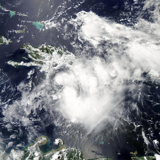
 BOSTON, Aug. 5, 2011 – According to catastrophe modeling firm AIR Worldwide, Emily remained stalled and disorganized in the Caribbean yesterday morning before finally reaching Haiti’s southwestern coast just before 5 pm EDT. As a result of interaction with Haiti’s mountainous terrain, the storm—at tropical storm-strength earlier in the day—rapidly degenerated. As of 5pm EDT last night, Emily had dissipated completely. It is now a remnant low pressure system, lacking a closed surface circulation. Even though the system’s winds are not a threat, rain and flooding are. Precipitation from Emily could cause flash floods and mud slides in Hispaniola today.
“Yesterday, as Emily tracked toward Hispaniola, there was significant uncertainty not only as to the storm’s track but also as to its future intensity, said Scott Stransky, scientist at AIR Worldwide. “Some global models predicted the storm would weaken. Because the storm was so disorganized and did not extend far into the atmosphere vertically, it was not influenced by steering currents in the same way a more organized storm would have been. Instead of being driven northward by upper level steering currents, it was driven further westward by lower level winds.”
Already, the capital, Port-au-Prince—large parts of which remain in disrepair after last year’s earthquake—has experienced significant rainfall. Heavier precipitation fell further north, damaging homes as well as a cholera treatment center, according to the country’s civil defense director. Outside the capital city, buildings are of poor construction and are subject to damage by flooding and mudslides.
Hundreds of homes in Haiti have been damaged so far. In the rice-farming village of L’Estere in Haiti’s Artibonite Valley, at least 50 homes were threatened by flooding. The Artibonite is especially flood-prone because the surrounding mountains have been deforested.
In the Dominican Republic, Emily delivered more than 140 millimeters of rain around the southwestern city of Barahona. The high water has collapsed bridges, cutting off a string of towns in the southwest of the country. Crop damage has been reported, as has light damage to structures and some damage to electrical plants in the eastern part of the country. Provinces in the Dominican Republic impacted by flood damage include San Pedro de Macorís, Monseñor Noel, Barahona, Azua, La Romana, Samana, Santo Domingo, Bahoruco and Monte Plata, though the majority of the damage in these areas is to uninsured structures. AIR does not expect significant insured losses from flood.
Wind damage will also be minor, in light of Emily’s dissipation. According to AIR, the residential building stock in Haiti primarily consists of unreinforced masonry structures; commercial buildings are typically made of reinforced masonry construction, and typically performs well in both wind and flood scenarios.
“Emily’s current fate is very uncertain,” explained Stransky. “It is possible that the remnant low pressure system will regenerate into a tropical storm (there is a 60% chance of this as of the 2pm National Hurricane Center update this morning) after passing Cuba and entering the Southern Bahamas, where the environment will be more conducive to development.”
Given that the storm’s winds have dissipated, that flooding is mostly impacting non-insured properties, and that the insurance penetration in Haiti is extremely low, AIR does not expect insured losses to be significant.
AIR is continuing to monitor Emily and will provide additional information as events warrant.
