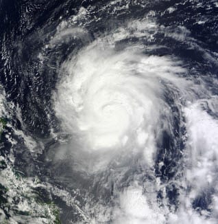
 BOSTON, Sept. 30, 2011 — According to catastrophe modeling firm AIR Worldwide, Typhoon Nalgae (named “Quiel” by the Philippines state weather bureau, PAGASA) formed on September 24 east of Guam from an area of convection with a weak low-level circulation center. Over the next several days, Nalgae became better organized under moderate vertical wind shear and high sea surface temperatures of 29°C-30°C. It strengthened to tropical storm strength and was named by the Japan Meteorological Agency (JMA) on September 26. Nalgae is the nineteenth named tropical cyclone of the 2011 Northwest Pacific typhoon season, according to the JMA.
“A deep subtropical ridge-the same ridge that steered Typhoon Nesat to a landfall in the Philippines earlier this week-is limiting poleward movement, keeping Nalgae on a nearly due west course,” explained Dr. Peter Sousounis, principal scientist at AIR Worldwide. The storm is expected to make landfall in Cagayan province on Saturday morning, local time.
“Due to strong steering, Nalgae is moving west at a fast forward speed of 30 km/h, which is resulting in low to moderate rainfall accumulations on the order of 150-200 mm, according to the Tropical Rainfall Measuring Mission (TRMM),” said Dr. Sousounis. “Additionally, Nalgae is a relatively small storm, with a 10 km eye and gale-force winds extending 200-250 km from the center. Due to the smaller storm size and forecast track (with an expected landfall some 100-150 km north of Nesat’s), Manila should be spared from any significant wind or flood damage.”
Typhoon Nalgae has undergone a period of steady intensification, with the central pressure falling from 980 mb to 940 mb over a 27 hour period ending at 12 UTC 30 September. According to the JMA’s 12:00 UTC update (8 pm local time), Nalgae is located approximately 625 km northeast of Manila. Its central pressure is estimated at 940 mb and maximum 1-minute sustained wind speeds are 190 km/h, with gusts of up to 240 km/h. Nalgae is forecast to maintain its current intensity, with the possibility of slight strengthening, before making landfall, which is forecast to occur between 00 and 12 UTC on October 1.
On its forecast track, Nalgae is expected to traverse the entire width of Luzon Island. The largest impact will likely be from wind, and PAGASA has issued a Storm Signal No. 3 (third most severe out of four) for much of northern Luzon, warning of significant damage to residential structures (especially to roofing) and light industrial construction, and heavy losses to agriculture. Widespread disruption to electricity and communications is also expected.
Flooding does remain a concern, however, especially given that Nesat has already dropped copious amounts rainfall across the region (satellite estimates indicate that over 400 mm of rainfall have occurred across the Philippines in the last five days). “Although Nalgae will move quickly across Luzon, which will keep precipitation totals below 200 mm in low-lying areas, precipitation in the mountains could be significantly more and exceed 500 mm in some locations,” said Dr. Sousounis.
After reemerging over the South China Sea, Nalgae is forecast to reintensify slightly and generally continue on a westward path. A potential landfall near Hainan, China is possible sometime after October 4, although there is significant uncertainty in these long range forecasts.
“It is unusual for two tropical cyclones to impact the same region within such a short period of time,” added Dr. Sousounis. “This is only the fourth such case for Luzon, with the last instance being in 1992 when an astounding three tropical cyclones struck Luzon within ten days of each other.”
AIR will continue to monitor the progress of Typhoon Nalgae and will provide updates as warranted by events.
