According to catastrophe modeling firm AIR Worldwide, as of the National Hurricane Center’s 11:00 a.m. advisory, Tropical Storm Andrea is moving northeastward at a speed of 15 mph with maximum sustained winds of 60 mph and some stronger gusts. Tropical storm winds extend outward 140 miles but primarily to the east of the storm’s center. The storm is expected to accelerate and continue on a northeast path later today, making landfall in Florida’s Big Bend. Andrea is not expected to intensify further before making landfall and if forecasts hold AIR expects insured losses from wind damage to onshore properties to be minimal.
“Andrea’s winds do not pose a significant threat to engineered buildings such as mid- to high-rise public and private office buildings as well as well-mitigated homes in the storm’s path,” said Dr. Tim Doggett, senior principal scientist at AIR Worldwide. ” However, there could be isolated instances of damage to roof coverings and wall cladding of homes and low-rise non-engineered commercial structures such as warehouses and convenience stores. In addition, the winds could damage traffic lights and bring down signs. Precipitation-induced flooding is likely the greatest hazard from Andrea and could cause damage to single-family homes and other low-rise structures.”
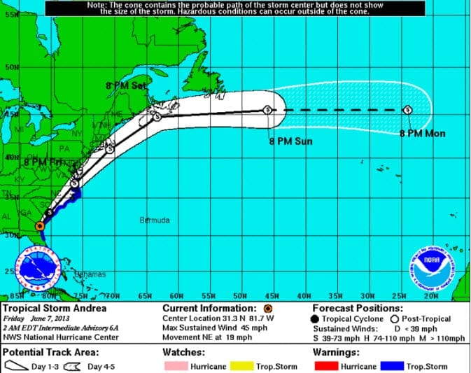
According to AIR, while Andrea poses no threat to U.S. oil and gas operations in the Gulf, the storm is expected to impact the Eastern Seaboard from northern Florida up to North Carolina as a tropical storm before weakening to a tropical depression early Saturday morning.
Image of storm path on June 7th – Wikipedia
Dr. Doggett stated, “Tropical storm winds will begin to impact Florida’s west coast within the warning area later today and will slowly spread up the eastern seaboard. However, the greatest hazards from Andrea are anticipated to be the storm surge and heavy precipitation.”
Storm surge will bring rising waters to many coastal locations with the deepest water occurring near to and south of the Florida landfall location. If the storm surge coincides with high tide, water heights could reach 2 to 5 feet from Tampa Bay northward to Apalachicola and 1 to 2 feet from just south of Tampa Bay as well as in Flagler Beach northward to Cape Charles Light in Virginia.
Dr. Doggett concluded, “Andrea is expected to bring 3 to 6 inches of rain with isolated amounts of up to 10 inches over much of the Florida Peninsula, eastern parts of the Florida Panhandle and southeastern Georgia. Eastern locations of South Carolina and North Carolina as well as southeastern Virginia will likely receive 2 to 4 inches of rainfall accumulation.”
The National Hurricane Center also states that tornadoes are probable over the Florida Peninsula later today.
AIR will continue to monitor the situation and will provide updates as warranted by events.

