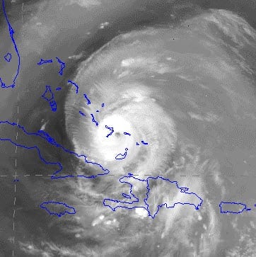
 BOSTON, Aug. 24, 2011 — As of the National Hurricane Center’s 8:00 am EDT advisory, Category 3 Hurricane Irene is battering the southern Bahamas with sustained winds of 115 mph. According to catastrophe modeling firm AIR Worldwide, Irene is currently 55 miles southeast of Acklins Island and 335 miles southeast of the capital Nassau. The storm is moving to the west-northwest at 9 mph. The center of the storm is headed directly for the Crooked and Acklins Islands, both sparsely populated (estimated population about 880 combined) and characterized by agriculture and small fishing villages.
According to AIR, the dominant residential construction types in the Bahamas are reinforced and unreinforced masonry; commercial structures are commonly made of reinforced masonry and reinforced concrete. Non-engineered structures can experience significant damage to roof and wall claddings when subjected to Category 3 wind speeds and there will be instances of structural damage, particularly to poor-quality homes. Engineered structures can sustain significant non-structural damage and damage to unprotected windows caused by flying debris. Light metal buildings, which are common in small and large industrial facilities in these regions, may sustain significant damage. Building code enforcement in the Bahamas is relatively high.
Given the large number of hotels in the region, business interruption losses may also be significant due both to direct physical damage and damage to supporting utilities. Hotels can suffer significant damage to their outer cladding and contents at Category 3 wind speeds.
“Yesterday, Hurricane Irene lashed the Dominican Republic with heavy rain and gusty winds, leaving 200,000 households without power,” said Scott Stransky, scientist at AIR Worldwide. “Fortunately, a northward shift in the track kept Irene offshore, leaving coastal exposure on the left-hand, weaker side of the storm. Still, homes and streets were flooded by up to 10 inches of rainfall in some areas, and trees and power lines were downed. AIR currently expects the bulk of insured losses in the Dominican Republic to be the result of flooding.”
Haiti was spared the worst of Irene, as the storm remained well offshore. Heavy and continuing rain could still cause some flooding and mudslides. The government, however, has reported no significant damage.
By the NHC’s 5:00 pm EDT advisory yesterday, Irene had entered an area of vertical wind shear of 10-20 knots and the storm was downgraded to Category 1 as it passed west of the Turks and Caicos Islands. Storm surge was expected to raise water levels 5 to 8 feet above normal tide and rainfall accumulations of 6 to 12 inches were possible in the Turks and Caicos and southeastern Bahamas.
Stransky continued, “By 2:00 am this morning, Irene had regained its Category 2 status. By 8:00 am the storm was a major hurricane-Category 3 with sustained winds of 115 mph. Central pressure is currently 957 mb and sea surface temperatures are warm, and thus favorable for some further intensification. The current intensity forecast from the NHC is for wind speeds to reach 125 mph or more over the course of the next 24 hours and to maintain that intensity as the core of Irene passes New Providence and the capital Nassau.”
“The current NHC forecast track has Irene passing over the eastern edge of the Bahamas for most of today and tomorrow, east of Nassau, but very close to Marsh Harbour. However, even a slight westward movement could bring much more intense winds to the Bahamas-and it should be noted that some of the dynamical forecast models show the eye of Irene passing directly over Nassau. In any event, the largest cities of the Bahamas-Nassau, Freeport and Marsh Harbour-are likely to experience damaging winds and high waves. Irene is a large storm. Hurricane force winds currently extend outward up to 40 miles from the center and tropical storm force winds extend outward to 205 miles. A storm surge of up to 11 feet above normal tide levels is expected over the low-lying central and northwestern Bahamas.”
Slight eastward shifts in the forecast track throughout the day yesterday calmed nerves in Florida and shifted attention instead to the Carolinas. After passing through the Bahamas, Irene is expected to curve to the north towards North Carolina’s Outer Banks on Saturday. The most likely scenario, currently, is that Irene will brush by the barrier islands, just offshore, and then make its way towards New York City, possibly as a Category 1 hurricane, and Boston by Sunday, possibly as a Category 1. It is important to emphasize, however, that such long-range forecasts are associated with considerable uncertainty. A slight westward-or eastward-shift in the track will have significant implications for damage and loss.
AIR continues to monitor Hurricane Irene closely and is simulating the storm’s effects. Additional information about losses will be made available after the storm has finished impacting all the Caribbean islands, which-on the NHC’s current track-will be by Friday morning EDT.
